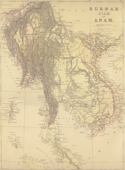
Welcome to a free download of this map showing present day Myanmar (Burma), Thailand, Cambodia, Laos, Vietnam and the northern part of peninsula Malaysia.
Click on the map below to obtain the high resolution 2MB map zip file.
It was published by Blackie & Son, a Glasgow bookseller. Today if you Google "Blackie & Son map" You will find many antique maps for sale. You can find more about the company on Wikipedia by following the link here. I found this map in a Singapore shop selling old prints.
This scan was made in 1998 and the file size is just over 2MB. The original scan size was just over 1MB and chosen to fit on a 1.44MB computer diskette to be given away at a lunch in Bangkok for members of the UK based Thailand Philatelic Society who either lived in or were visiting the city.
It will be of interest to anyone interested in late 19th Century Southeast Asia and to stamp collectors interested in the Anglicized town names of the period. You can find the download zip file here.
This map was published during the reign of Siam's King Chulalongkorn, Rama 5, who reigned from 1868-1910. His father King Mongkut, Rama 4, was rather inaccurately portrayed in both in the Anna Leonowens book and by Yul Brynner in the movie The King and I.
King Chulalongkorn was a modernizer and he had to change the country during a period of aggressive French and British colonial expansion. The French-British rivalry led to an agreement between these powers to leave Siam as a buffer state between French Indochina and British Burma and Malaya. This was ratified as a clause the famous 1904 Entente Cordiale agreement.
The British nibbled away parts of Siam's control of peninsula Malaya and Northeastern Burma while the French would take back those parts of Cambodia and Laos under Siam's suzerainty. The 1886 map shows some of these regions as still part of Siam.
Under King Chulalongkorn we see the introduction of a postal service in 1883 and the first railway built in 1890. At the time of this map travel in Bangkok was mainly by canal and in the northern teak forests by elephant. Siam was an important exporter of both teak and rice. Chinese labour was bought in as most of the Thai population was involved in peasant farming.
For examples of this map please click here.
You will see on the map the old British spelling of the country's name as Burmah. From 1989 the country's name has been Myanmar. In the 18th Century and early 19th Century the Burmese empire reached its zenith. Under a Bamar (the largest of the ethnic groups that make up present day Myanmar) royal dynasty was expanding into the east of the Indian subcontinent.
This is where the strong Burmese military initially clashed with British forces. Both Britain and France had been looking for a commercial relationship with Burma in their expanding colonial interests. The First Anglo-Burmese War of 1824-1826 halted Burmese expansion and bankrupted the Burmese treasury. With the Second Anglo-Burmese War of 1852-1853 lower Burma was ceded to British control. In the final Third Anglo-Burmese War of 1885 Britain took control of the entire country. On the 1st January 1886 Burma was officially annexed by Britain.
This makes the 1886 map interesting as it shows the position prior to the beginning of 1886. The lower portion of the country is shown as British Burmah as per the results of the Second Anglo-Burmese War of 1852-1853. The middle portion is shown as Independent Burmah while across the north of the country we see markings of "Independent Tribes" and "Independent Shan Country".
For examples of Burma-Myanmar on the map please click here.
Again the 1886 map covers a period of colonial expansion in Southeast Asia. For present day Vietnam this was French expansion. The map refers to the region as Anan although the more common spelling would be Annan. The southern third of the country became French Cochin China during the 1860's. In 1884, two years before the map was published, the entire country was under French rule with two protectorates. Annan was the central region and Tonkin , spelled Tonquin on the map, in the north. We see areas marked as being "Independent Tribes" in the northwest.
For examples of this map please click here.
During the 12th Century the Khmer Empire ruled from Angkor controlled much of Southeast Asia. By the 15th Century it was in decline facing warlike ethnic groups with the Thais to the west and the Chans to the east. The Siamese-Vietnamese War of 1841-1845 left the country under joint suzerainty of Siam and Vietnam.
In 1867 Siam gave up control of all its Cambodian land except for the provinces of Battambang and Siem Reap which became part of Siam. The same year Cambodia became a protectorate of France. This 1886 map still shows much of Cambodia being under Siam.
For an example of this map please click here.
The majority ethnic group in Laos was the Tai coming from the same ethnic movement out of China as the Siamese. By the beginning of the 19th Century Laos was under the control of Siam and a Lao rebellion in 1826 against Siam was brutally put down. Many Laos were taken as slaves by the Siamese.
In the late 19th Century Laos became a French protectorate and part of its Indochina colonies. The map shows it as still being under Siamese control.
For an example of this map please click here.
The 1886 map shows the northern Malay peninsula as being under Siamese control. The one region shown as being under British control is Penang island. In 1826 in the Burney Treaty Britain acknowledged Siamese control of Kedah, Terengganu, Kelantan and Pattani while granting Britain control of Penang island and its mainland neighboring region.
It wasn't until the 1909 Bangkok Treaty that Siam ceded much of its control of the northern Malaya to the British and the modern-day border was established.
For an example of this map please click here.
National Geographic map of Southeast Asia
From Nancy Chandler still the most fun maps of Bangkok and Chiang Mai. Perfect for visitors hoping to discover where to go in these two Thai cities.
Bangkok Digital Map...Nancy Chandler's Map of Bangkok (Full Package with Directory)
Chiang Mai Digital Map...Nancy Chandler's Map of Chiang Mai (Full Package with Directory)
...
Thaimaps.com domain name is for sale. Please click here to find it on Sedo.com